Looking for privacy, big skies, and quick access to Geneva Lake? If you’re considering an estate or large acreage in Linn Township (the Town of Linn), you’re shopping in one of Wisconsin’s most sought-after lake-country markets. You want space, but you also care about lake use, future build options, and long-term value. This guide breaks down the property types you’ll see, the rules that shape what you can do, and the due diligence steps that protect your investment. Let’s dive in.
Why Linn Township draws estate buyers
The Town of Linn wraps much of Geneva Lake’s north and south shores and preserves a low-density, rural feel. The Town’s land-use framework favors limited growth and conservation-minded development that protects open space and scenic character. You can review the Town’s planning and land-use priorities on the official Land Use page for details on preferred patterns and zoning references. Town of Linn Land Use
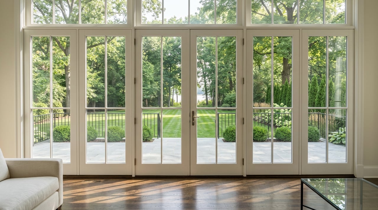
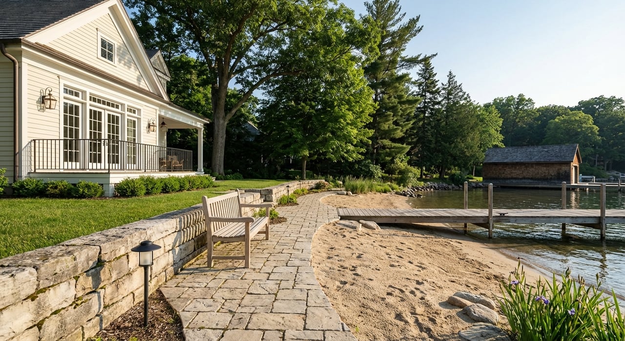
Geneva Lake remains a rare amenity with limited true lakefront supply. That scarcity supports a distinct luxury segment where well-positioned waterfront and near-lake estates trade in a different band than typical inland homes. Proximity to water and the type of lake access a property holds are major value drivers.
For boating access, the Town maintains two public launches with posted rules and pay stations. If a property you’re considering is not riparian, nearby public launch options can still support your boating lifestyle. Town of Linn public launches
Estate and acreage property types in Linn
Lake-neighborhood lots with lake access
You’ll find smaller parcels within historic lake neighborhoods that include association beach rights, path access, or private pier easements. These often sell as premium second homes because they deliver lake use with a lower land footprint. Always confirm exactly what the deeded access allows, including pier or mooring rights, fees, and waitlists.
Mid-acreage country estates
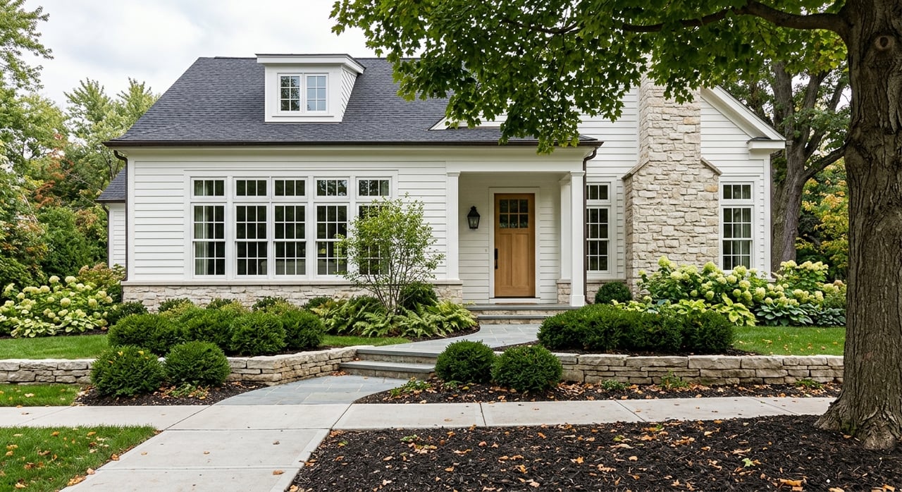
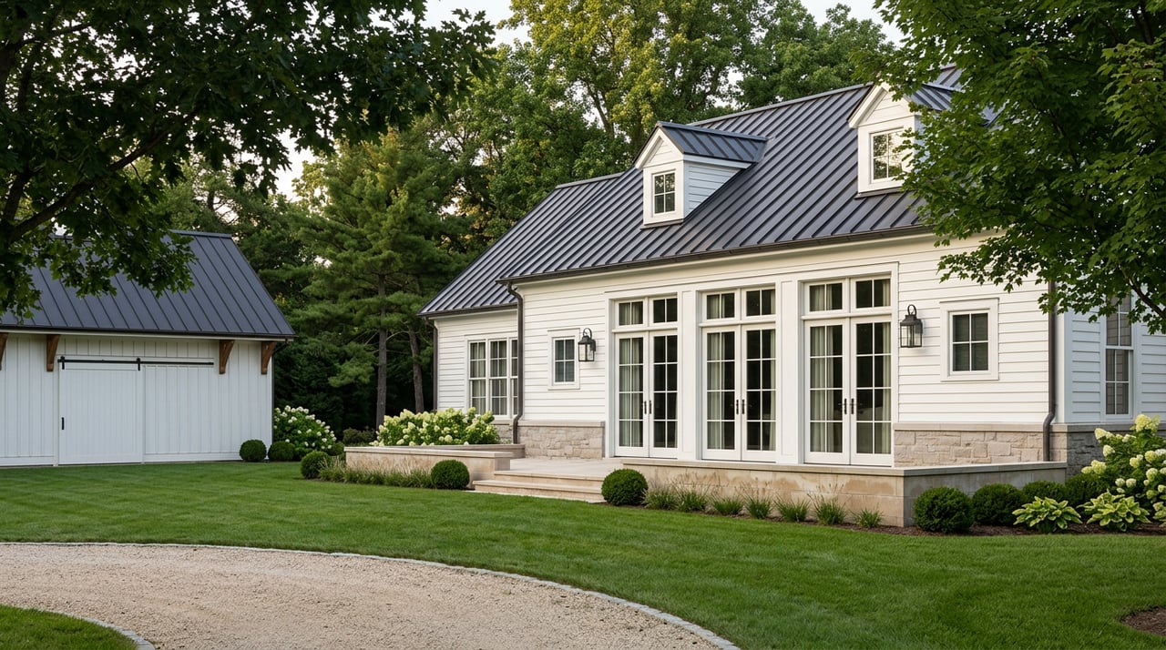
Parcels from roughly 1 to 20 acres are common and may combine lawns, mature woods, and rolling ridgelines. Many offer privacy and, in some cases, partial lake views without direct frontage. You’ll also see family compounds with main houses and tasteful outbuildings for hobbies, collections, or guests.
Large agricultural and woodland tracts
Twenty acres and up, including actively farmed land or forested conservation candidates, appear at intervals. The Town’s plan points buyers and developers toward conservation subdivision concepts that cluster homesites and preserve open space at lower densities. Outside urban service areas, the preferred density for residential conservation subdivisions is one unit per five acres, subject to County zoning district rules. Town of Linn Land Use
Improvements and outbuildings to expect
Country estates often include barns, equestrian facilities, workshops, detached garages, and guest quarters. These structures are regulated by the Town and County and may be limited by zoning, lot coverage, and septic capacity. Plan early if you need new or expanded outbuildings so you can match design to code and utility limits.
On waterfront parcels, expect piers and seasonal docks, and occasionally legacy boathouses. Their size, placement, and legality are controlled by state law and local ordinances, and many structures predate current rules. Confirm permit status and the property’s history before you rely on an existing pier or shoreline improvement. Wisconsin water law explains when state permits are required and how nonconforming structures are treated. Wisconsin water law guide
Key regulations that shape what you can do
Zoning and planning basics
The Town’s Comprehensive Plan and the County’s zoning map work together to guide what you can build and where. Always verify a parcel’s zoning district, setbacks, allowed uses, and any overlays with Walworth County Land Use & Resource Management (LURM). Early contact with LURM reduces surprises and sets a clear path to permits. Walworth County LURM
Shoreland rules on Geneva Lake
Most property within 1,000 feet of Geneva Lake’s ordinary high-water mark sits inside a shoreland zoning overlay. This adds rules on setbacks, impervious surfaces, and protected vegetation zones that can affect building, patios, driveways, and grading. Review the County’s guide to understand standards and timing before you design. Shoreland Zoning Guide
Piers and boathouses
Piers, boathouses, and shoreline work are regulated under state Chapter 30 and local ordinances. Some municipalities set pierhead lines that limit length and placement. Many older piers exist legally but have nonconforming status, which can limit changes. Require written proof of lawful status and any local pier-numbering or registration. An example of municipal pier standards is available in the Williams Bay code. Williams Bay pier rules example | Wisconsin water law guide
Septic systems and wells
Outside municipal sewer areas, new or replacement private onsite wastewater systems (POWTS) require County permits. Expect soil evaluations, approved system design, and ongoing maintenance reporting, typically every three years. For large estates or additions, confirm both system capacity and site constraints before you expand. Walworth County Sanitation
Land divisions and conservation subdivisions
If you plan to split a large tract, both the County Subdivision Ordinance and the Town’s conservation-first policies apply. Minimum lot sizes, frontage, and open-space requirements vary by zoning district. Coordinate early with the Town and LURM to map a realistic timeline and layout. Town of Linn Land Use
Your due diligence roadmap
Use this checklist to move from interest to confident close.
- Title, parcel IDs, and easements
- Pull the parcel record in Walworth County’s GIS OneView to locate recorded easements, historic Certified Survey Maps, and right-of-way notes. Then order a title commitment with extended coverage. Walworth County GIS OneView
- Boundary and topographic survey
- Commission a current boundary survey. For any property near water, ask the surveyor to locate the ordinary high-water mark and note existing shoreline structures. Add topo if you’re planning site work.
- Zoning and overlays
- Request LURM confirmation of zoning district, shoreland overlay status, setbacks, maximum impervious surface, and any environmental corridors. Ask about procedures for variances or conditional uses if you anticipate them. Walworth County LURM
- Septic and well checks
- Retrieve septic permits and maintenance history, and schedule inspections as needed. If you plan renovations or more bedrooms, budget for soil testing and a new system design. Test the well for coliform, nitrates, and other common contaminants. Walworth County Sanitation
- Shoreland, wetlands, and floodplain
- In shoreland areas, review the County guide for impervious and setback rules. Order a wetland delineation if mapping suggests constraints and confirm any floodplain impacts before you design. Shoreland Zoning Guide
- Lake access and riparian rights
- Verify whether the parcel is riparian or uses an association or deeded easement. Read the recorded language to confirm pier or mooring rights and any waitlists or fees. Check municipal pierhead lines and local ordinances where relevant. Williams Bay pier rules example
- Utilities and broadband
- Confirm electrical service, natural gas or propane, and internet options at the driveway. Rural service can vary by street and provider. Plan for generators or alternative solutions if you need redundancy.
- Roads and access agreements
- Determine if access is via a public or private road. If private, locate the recorded maintenance agreement, define plowing and repair responsibilities, and check any weight or width limits for construction deliveries. Town of Linn Land Use
- Fire/EMS coverage and insurance
- Ask the Town about current Fire/EMS arrangements and response expectations. Get early quotes for home, liability, and marine insurance, especially for lakefront and wooded acreage. Town Fire/EMS partnership
- Conservation easements and programs
- Search recorded documents for conservation easements or restrictive covenants. If you value permanent open space or potential tax benefits, consult local land-trust resources for options. Geneva Lake Conservancy programs
- Taxes and special assessments
- Review recent tax bills and ask the municipality about any planned projects or assessments that could affect carrying costs.
- Permitting schedule and soft costs
- Build a realistic calendar that includes surveys, soil tests, design time, pre-application meetings, and public hearings if needed. Account for mitigation measures in shoreland areas and professional fees.
Access to Geneva Lake and value drivers
- Type of access. Riparian frontage with a lawful, usable pier is rare and carries a premium. Association or easement access to a beach or pier can deliver strong lifestyle value at a different price band. Confirm the exact rights in writing.
- Shoreland position. Parcels inside the shoreland overlay face more rules on setbacks and impervious surfaces, which affects design and timeline. Proper planning preserves value.
- Setting and views. Wooded ridgelines, long drives, and curated landscaping add privacy and a sense of arrival. Partial lake views or proximity to a public launch can elevate day-to-day use.
- Future potential. Room for a guest cottage, sport court, or a larger garage can be a major upside. Zoning and septic capacity set the limits, so validate early.
Common red flags and buyer leverage points
- Pier ambiguity. Unclear easement language or an unpermitted pier can derail lake plans. Require proof of lawful status and any local registrations. Williams Bay pier rules example
- Unpermitted shoreline work. Unauthorized fill, retaining walls, or vegetation removal in shoreland buffers can trigger remediation orders. Confirm permits and as-built conditions. Shoreland Zoning Guide
- Septic limits. Existing POWTS capacity can cap bedroom counts or guest use. Get records, inspections, and, if needed, a replacement plan. Walworth County Sanitation
- Hidden easements or corridors. Road, utility, or conservation easements can affect siting and privacy. Cross-check the County GIS and title. Walworth County GIS OneView
- Conservation restrictions. Recorded easements or covenants may limit subdivision or tree removal. Verify with the Register of Deeds and consult local conservation resources. Geneva Lake Conservancy programs
How we help you buy in Linn
Buying an estate or acreage near Geneva Lake is equal parts vision and verification. You set the lifestyle and privacy goals. We help you match them to the right parcel, confirm the path to permits, and negotiate with clarity. With deep local roots and a boutique, high-output approach, you get attentive guidance and streamlined coordination from search to close.
If you’re ready to explore Linn Township estates or want a quick read on a parcel’s access, zoning, or shoreland rules, reach out for a confidential consult with Tricia Forbeck. We’ll help you move forward with confidence.
FAQs
What counts as riparian rights on Geneva Lake in Linn?
- Riparian rights apply when your parcel directly fronts the lake, allowing certain shoreline uses like a pier if lawful under state and local rules; association or deeded access is different and must be verified in recorded documents.
How does shoreland zoning affect new construction on acreage?
- Parcels within 1,000 feet of Geneva Lake face added setbacks, impervious-surface limits, and vegetation protections that shape home and driveway placement and may extend timelines.
What should I check about septic systems on a country estate?
- Confirm the system type, capacity, permits, and three-year maintenance reports; plan for a soil evaluation and new design if you add bedrooms or expand the footprint.
Are new piers or boathouse changes allowed on Geneva Lake?
- It depends on state Chapter 30 rules, any municipal pierhead lines, and whether the structure is conforming; many older piers can be used but have limits on expansion or alteration.
How do conservation easements affect large tracts in Walworth County?
- A recorded conservation easement can restrict subdivision, building envelopes, and tree removal; review documents and consult local land-trust resources before you plan improvements.
What’s the best way to verify boundaries and easements before I buy?
- Order a boundary survey and review the County GIS parcel record alongside a title commitment with all recorded easements, CSMs, and right-of-way notes.